Technical4 Apr 20265 min read
Understanding GPS vs RTK: Which Positioning System Does Your Drone Need?
Your drone knows where it is. But how accurately — and does it matter for your mission?
Every drone flying today has some form of positioning system onboard. It's what keeps a quadcopter hovering in place when you let go of the sticks. It's what allows a mapping drone to fly a precise grid pattern over a construction site. It's what brings a waypoint mission home accurately after 45 minutes in the air.
But not all positioning is created equal.
There's a gap — sometimes a small one, sometimes a critically important one — between standard GPS and RTK positioning. Understanding that gap determines whether your drone data is useful or useless for the application you're running.
Start With the Basics
GPS — Global Positioning System — works by triangulating signals from multiple satellites orbiting the Earth. Your drone's GPS receiver picks up those signals, calculates timing differences, and determines its position.
In ideal conditions, a consumer-grade GPS gives you 2–5 metre horizontal accuracy. That's fine for flying, for return-to-home, and for general navigation. For most recreational and basic commercial uses, it's completely adequate.
The problem starts when you need more precision than that.
A 3-metre position error on a surveillance drone doesn't matter much. A 3-metre position error on a drone collecting survey data for a construction site — where you're trying to detect 10cm elevation changes — makes your data worthless.
That's where RTK comes in.
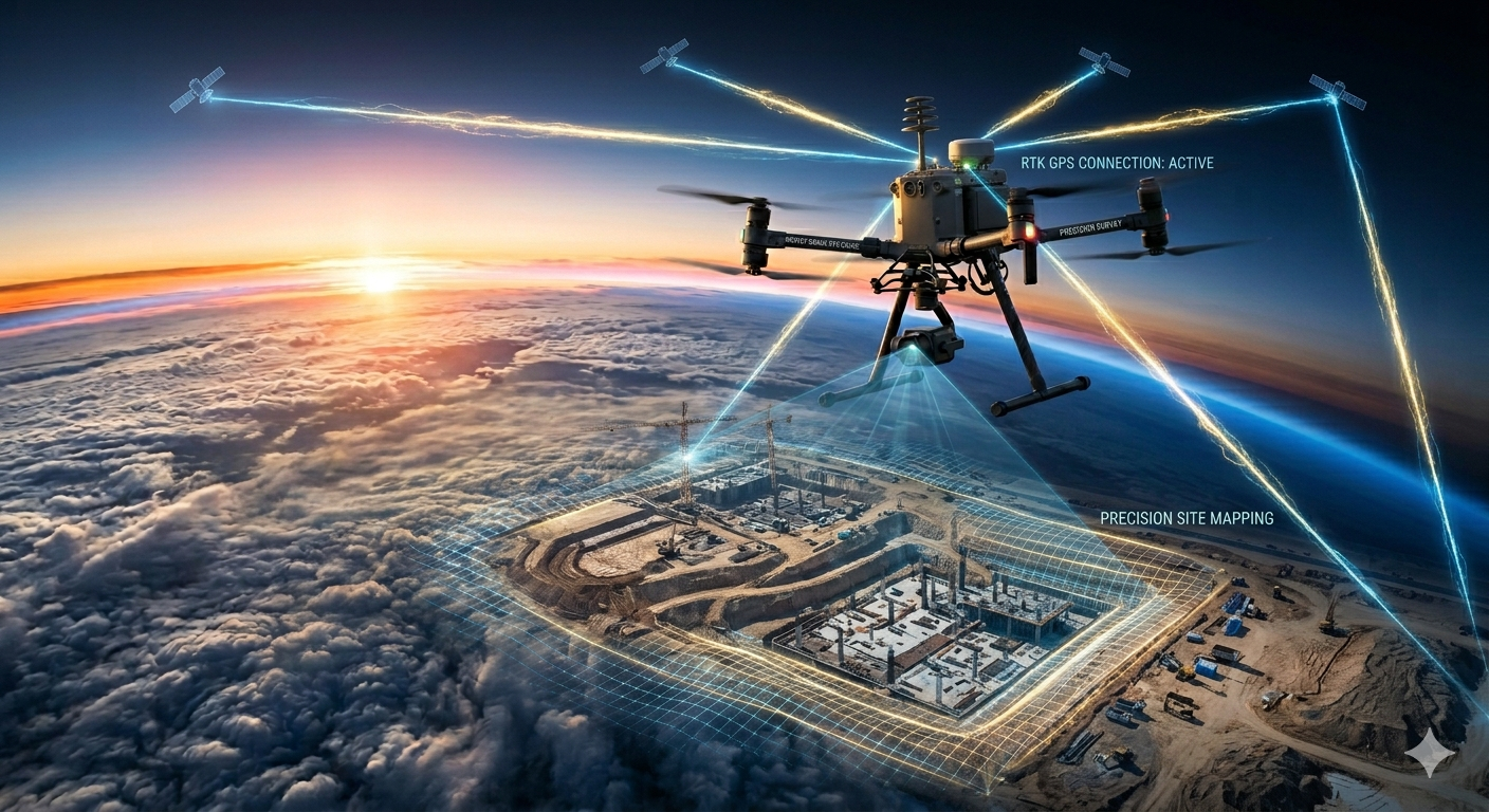
What RTK Actually Does
RTK stands for Real-Time Kinematic. It's a positioning technique that uses a secondary reference point — a base station — to correct the errors in GPS signals in real time.
Here's the simple version of how it works:
The base station sits at a known, fixed location on the ground. It receives the same GPS signals your drone is receiving. But because the base station knows exactly where it is, it can calculate the errors in those signals — atmospheric interference, satellite geometry problems, signal multipath — and broadcast corrections to the drone.
The drone's RTK receiver applies those corrections on the fly. The result is positioning accuracy in the 1–3 centimetre range — roughly 100 times more precise than standard GPS.
That shift from metres to centimetres isn't just a technical improvement. It's the difference between data that's directionally useful and data that's legally defensible for surveying, precise enough for infrastructure inspection, and accurate enough for volumetric calculations in mining operations.
The Real World Difference
Let's make this concrete with two scenarios.
Scenario A — Mapping a 50-acre construction site with standard GPS
Your drone flies a grid pattern and captures hundreds of overlapping images. The photogrammetry software stitches them into an orthomosaic and a digital elevation model. The output looks impressive — detailed, sharp, full coverage.
But every image has a position tag that's accurate to ±3 metres. When you try to use that elevation model to calculate earthwork volumes or check against engineering drawings, you're working with data that has built-in errors large enough to cause real problems. You'll need ground control points — physical markers placed across the site and measured with a total station — to correct the data before it's usable.
Scenario B — Same site with RTK
Same flight, same camera. But every image is tagged with centimetre-level position accuracy from the moment it's captured. Your orthomosaic and elevation model come out of the software already georeferenced accurately. Ground control points become a verification step rather than a correction requirement. The workflow is faster, cheaper, and the output is immediately usable.
Types of RTK Setup
There are a few different ways to access RTK corrections — each with different trade-offs.
Base station + rover is the traditional setup. You bring a physical base station to the site, set it up over a known point, and it broadcasts corrections directly to the drone. Full control, works anywhere, no subscription required. But it adds equipment to carry and setup time to your workflow.
NTRIP / Network RTK uses a network of permanently installed reference stations — operated by government agencies or commercial providers — to deliver corrections over the internet to your drone via a mobile data connection. No base station required. Cleaner workflow. The limitation is coverage — NTRIP networks are dense in urban and developed areas, sparse in remote ones.
PPK (Post-Processed Kinematic) is technically different from RTK but worth mentioning here. Instead of applying corrections in real time, PPK records raw positioning data during the flight and applies corrections during post-processing. Slightly less convenient but often more accurate, and it works even in areas with poor connectivity.
So Which One Do You Actually Need?
The honest answer depends entirely on your application.
You probably don't need RTK if you're doing:
- General aerial photography or videography
- Basic site documentation where visual reference is enough
- Inspections where you're looking at visual condition, not precise measurements
- Search and rescue or surveillance operations
You almost certainly need RTK if you're doing:
- Topographic survey for engineering or construction
- Volumetric calculations for mining or earthworks
- Cadastral mapping or land boundary work
- Infrastructure inspection where dimensional accuracy matters
- Any deliverable that will be used in a legal or contractual context
The Cost Reality
RTK capability adds cost — both in hardware and workflow complexity. A drone with a good RTK module costs significantly more than its non-RTK equivalent. Base station equipment adds another layer of investment.
But that cost needs to be weighed against the alternative: manual ground control point placement, which requires additional field time, additional equipment, and additional processing steps. For high-frequency survey work on large sites, RTK pays for itself quickly in workflow efficiency alone.
The Bottom Line
GPS tells your drone where it roughly is. RTK tells it where it precisely is.
For casual flying and basic commercial work, roughly is enough. For survey, inspection, and any application where the data you collect has to be accurate enough to make real decisions — roughly isn't good enough.
Know what your mission requires. Then choose the system that actually delivers it.
GPSRTKDrone PositioningSurvey DroneAccuracy
Enjoyed this read?
Get articles like this delivered weekly — technical deep dives, industry news, and drone insights from India.
More in Technical
Technical5 MIN READ
ESC Protocols Explained: PWM, DSHOT, and What to Choose
The signal between your flight controller and motors is smaller than you think — and more important than most builders realize.
By The Drone Post

Technical5 MIN READ
How Flight Controllers Process Sensor Fusion in Real Time
Your drone is making thousands of decisions every second. Here's the invisible system making that possible.
By The Drone Post